When we left Texas (after 5 months!) we decided to take a boo at Arkansas. The first place we went was Crater of Diamonds State Park just outside of Mumfreesboro (just southwest of Little Rock). It was a nice park. Very woodsy! Crater of Diamonds Park is the only diamond mine (not operated any longer) in the U.S., and it's the only one in the world that is publicly accessible. They have some amazing records of this mine. The largest diamond found there was a 40 carat beauty found in the early 1900's. The latest large find here was a 6.8 carat diamond found in 1997. There's still one or two diamonds found every day by folks who come here. Mary enjoyed the day, but I'm quickly bored and ended up wandering around. Basically, the mine consists of a large field of dirt that people poke through to find diamonds. This is the entrance to the diamond field. Ya pay yer $7 and go lookin'. They'll rent ya shovels, screens & pails if you need 'em.
 This is part of the field (crater). They occasionally come in and plow the field to turn the dirt and provide new dirt to poke in.
 And here's folks pokin'! The thing is, ya kinda go with the idea yer pokin' through sand and it's really clay. They say the best time is right after a rain, 'cause the dirt tends to wash away and leave the diamonds (heavier) sitting on top of the dirt. Dirt won't stick to diamonds. We didn't find anything, but some lady was purported to have found a $400 stone while we were there. Yer lookin' for something anywhere from the size of a grain of sand to a small pea. Interesting, but one day was enough for me.
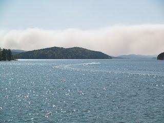
 See the trees sticking up out of the water in these two pics? They used to be islands! They'll be back in the fall.
 There are different rock formations throughout the lake. Lots of shale and slate and stuff. This pic is one of the places where you can find clear quartz crystals, so people boat over and climb 'em lookin'.
 This is the entrance to the diamond field. Ya pay yer $7 and go lookin'. They'll rent ya shovels, screens & pails if you need 'em.
 This is part of the field (crater). They occasionally come in and plow the field to turn the dirt and provide new dirt to poke in.
 And here's folks pokin'! The thing is, ya kinda go with the idea yer pokin' through sand and it's really clay. They say the best time is right after a rain, 'cause the dirt tends to wash away and leave the diamonds (heavier) sitting on top of the dirt. Dirt won't stick to diamonds. We didn't find anything, but some lady was purported to have found a $400 stone while we were there. Yer lookin' for something anywhere from the size of a grain of sand to a small pea. Interesting, but one day was enough for me.
Arkansas is very mountainous. We left the "Crater" and went to Ouachita State Park. It's in the Ouachita mountains just outside of Hot Springs. Btw, Ouachita is pronounced "Wash-i-taw. Neither Mary, nor the truck was impressed with the drive. Very hilly, very twisty-turny. and very narrow roads with no shoulders! But, the park was georgeous!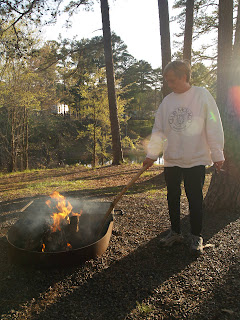 Mary finally got her campfire! Hey Tim, recognize the stick??
 Mary finally got her campfire! Hey Tim, recognize the stick??
This is Mary walking around the shore right by our campsite.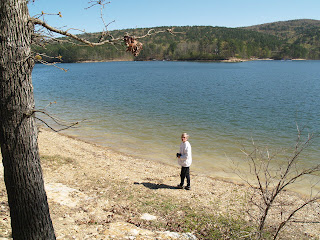 These next three pics are taken right from our campsite (love the sunset pic).
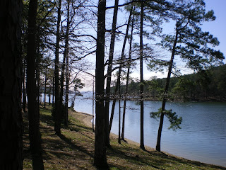

 These next three pics are taken right from our campsite (love the sunset pic).


We went into Hot Springs to take a look around. Once we took the wrong turn on the way into Hot Springs and ended up on an OLD road through the National Park to get to the city. Man, what a road. There was one part where you made a tight turn, climbed a long 25 degree hill (that's what the sign said!) with another tight turn and drop at the top. Poor Mar' was damned near hysterical by the time we got off that road! But we finally got into town. Really interesting! They've preserved all the old buildings from their "hay-days. The town was a Mecca for the elite in the '20's and '30's. Lots of famous people and the gangsters (Capone, etc.) would go there for the mineral baths.


 Some of these bath-houses are still in operation, and one of them has be converted to a museum
 so you can see what it was like in the '20's.
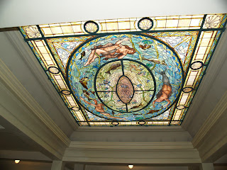 Lots of marble, granite, statuary, and imported ceramic tile. This stained glass ceiling has over 8000 pieces in it!
 Snazzy after-bath lounge areas, etc. These places were the cat's meow (bee's knees???) for their time. And the water from the hot springs supposedly had (has) lots of curative powers. People still fill bottles at the public areas to drink!
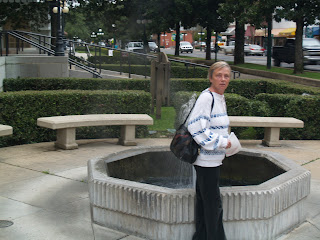 I don't know whether you can see the steam coming off the fountain behind Mary, but this water's hot!
 The story is that rain water sinks into the ground all over the area through faults in the rocks. It sinks at about 1 foot per year. it takes the water about 8000 years to desend to the 8000 foot level where it's heated to about 150 degrees f (77 deg. c) and expansion causes the hot water to ascend very quickly so it gets back to the surface at about 143 deg. f (75 deg. c). They actually have to cool it down somewhat for the baths. It was a very interesting window to the lifestyle of the wealthy in the '20's and '30's. We didn't get any pics that would show this, but we hiked to the top of Hot Springs mountain, about 3 k! Whew! But we found a real quick (and steep) 1/4 k. route down. Folks were impressed that we did the climb.


 Some of these bath-houses are still in operation, and one of them has be converted to a museum
 so you can see what it was like in the '20's.
 Lots of marble, granite, statuary, and imported ceramic tile. This stained glass ceiling has over 8000 pieces in it!
 Snazzy after-bath lounge areas, etc. These places were the cat's meow (bee's knees???) for their time. And the water from the hot springs supposedly had (has) lots of curative powers. People still fill bottles at the public areas to drink!
 I don't know whether you can see the steam coming off the fountain behind Mary, but this water's hot!
 The story is that rain water sinks into the ground all over the area through faults in the rocks. It sinks at about 1 foot per year. it takes the water about 8000 years to desend to the 8000 foot level where it's heated to about 150 degrees f (77 deg. c) and expansion causes the hot water to ascend very quickly so it gets back to the surface at about 143 deg. f (75 deg. c). They actually have to cool it down somewhat for the baths. It was a very interesting window to the lifestyle of the wealthy in the '20's and '30's. We didn't get any pics that would show this, but we hiked to the top of Hot Springs mountain, about 3 k! Whew! But we found a real quick (and steep) 1/4 k. route down. Folks were impressed that we did the climb.
The park ran a cruise on the lake, so we took it.  The lake is man-made. The dam is there basically for flood control. Boy, it don't take long either. The river was originally about 6' wide. The Dam is about 75' high. And it took about 3 1/2 years for the lake which is over 20 miles long and spread out like an octopus throughout the hills. Boaters have to be somewhat careful here, 'cause the lake level fluctuates with the seasons and island appear and disappear with the seasons.
 The lake is man-made. The dam is there basically for flood control. Boy, it don't take long either. The river was originally about 6' wide. The Dam is about 75' high. And it took about 3 1/2 years for the lake which is over 20 miles long and spread out like an octopus throughout the hills. Boaters have to be somewhat careful here, 'cause the lake level fluctuates with the seasons and island appear and disappear with the seasons.
 See the trees sticking up out of the water in these two pics? They used to be islands! They'll be back in the fall.
 There are different rock formations throughout the lake. Lots of shale and slate and stuff. This pic is one of the places where you can find clear quartz crystals, so people boat over and climb 'em lookin'.
We stopped on a little island for a boo. Here's a pic for my kids, 'cause they LOVE my flower pics. Hey, I like it! Anyhow, we're off to Branson Missouri to take in a couple of shows for a week, then 4 more days and we're home. Later gang!
 Hey, I like it! Anyhow, we're off to Branson Missouri to take in a couple of shows for a week, then 4 more days and we're home. Later gang!

1 comment:
Great pics. Love the commentary too. I'm really quite envious of the trip you're having. You sure are seeing lots of neat things. Keep the notes and pics coming.....
Post a Comment